by Ishaan Kochhar and Amina Maharjan
 Community members interacting with satellite imagery of their region. These forms of discussions are further enriched by the responses collected from stakeholders. PC: Ishaan KochharNepal is experiencing a massive out-migration of the youth and labour migration is becoming an important factor in securing an alternative livelihood. Census data of 2011 indicates that 13 of the 19 districts of the Gandaki Basin have an absentee population of over 10%. It is a well-known fact that agriculture and remittance are the two main pillars of the economy in Nepal contributing to over 60% of the GDC. There is attribution here of the current state of agriculture in Nepal, to the absentee population in the basin.
There is a common Nepalese saying: ‘Panch padhyo halo chhodyo, Das padhyo thalo’, which literally translates to: ‘Those educated up to Grade Five leave the plough and those educated up to Grade Ten leave the village’. In a country like Nepal, where agriculture is the backbone of the economy, it is the main livelihood source for more than 80% of the rural population. Agriculture is portrayed as the occupation of uneducated and unskilled people. Therefore, educated youth prefer to migrate in search of better employment opportunities. A worrisome phenomenon has been observed in recent years, especially in the mid hills, of fertile agriculture lands being abandoned. At the same time, rural-urban mobility is having serious implications for downstream areas. Whatever studies on human mobility exist in Nepal, they do not give a clear picture of its scale and also often fail to analyse ground realities. So, there is little scientific evidence to support this narrative. To make it evident, we have used a mix of macro-scale top-down approaches (using geospatial and remote sensing) and bottom-up qualitative methods (in-depth interviews, focus groups discussion and participatory research).
 Abandoned houses such as these in the upstream regions in Nepal, support the story of migration. Through GIS based data on LULC and stories from the field, a wholesome narrative can be constructed.
The nexus between pixel, people, and migration
Satellite imaging is a composite of hundreds of thousands of pixels.A pixel is the smallest unit of an image under analysis. Each pixel of a satellite imagery represents a feature on the earth’s surface (agricultural land, forest, river, snow, mountains etc.). To make it simple, each pixel of a satellite image has a story to tell of the changing earth’s surface over the years.
In migration studies, human mobility becomes the point through which reasons for migration are determined. People migrate for many reasons including better economic opportunities and education. If the concept of the pixel is applied here, each individual migrant and their story, builds a larger picture that sets the context of mobility. Satellite images have the potential to improve our understanding of people-environment interaction.
Combining satellite imagery with the narratives of these migrants into one medium, means a cross-disciplinary understanding is required. This nexus is important as it allows for the exploration of the cause and extent of land use change. The nexus between migration and agricultural land use change is important, not only to explore the extent of land of use change but also the cause of it. Accordingly, the study has been designed to capture causes of scale together with location-specific cause. Satellite images can give a larger picture of agricultural land use change and a socio-economic survey can bring out nuances of causes. In this way, an inter-disciplinary methodology can help policy-makers understand this phenomenon at the national level. In addition to this, the adding of a remote sensing component to socio-economic fieldwork has enriched research in several respects.
 In this image the context for migration is ‘the need for water’. Topographical features would provide important physical information on slope, aspect and other factors motivating villagers to move into the valley below.
1. Determine the context of migration
Context may denote a variety of entities, including a political or administrative unit. Contexts may be measured in various ways. Because censuses obtain information on almost all individuals and households in a society, they can be aggregated to various units (block, neighbourhood, school district, city, county, or state) to provide measures of demographic or socio-economic characteristics of those units.
Remote sensing provides an additional means of gathering contextual data, particularly by describing the biophysical context (topography, land use, land cover, etc.), within which people live, work, and play.
2. Provide additional measures at low cost
Remote sensing provides a variety of additional indicators for research, including locations of major roads, hydrographic features, sources of irrigation, and types of crop. Gathering such measures at ground level might be possible, but is often prohibitively expensive because of the need to collect large amounts of small-scale data for aggregation. Remote sensing provides highly aggregated data at less cost.
3. Provide time-series data on past and present events
Time-series data is helpful when social scientists attempt to trace relationships of cause and effect. Remote platforms can provide time-series data of good comparability (i.e., the same variables measured in the same way across time) on variables of interest to social scientists concerned with the effects of environment on behaviour or with processes of people-environment interaction.
The ground truth of satellite remote observation
Remote sensing practitioners are well aware of the need for ‘ground truth’, that is, for validating remote observations against data collected on the ground. There are some kinds of ground validations that involve classifying remote observations into more obviously land cover categories, and these depend on social science inputs. An important example in our study is the identification and classification of abandoned agricultural land, which is socially defined in ways that do not correspond to categories of abandoned land as observed from satellite images. For example, some areas were classified as tree cover, some as shrub and grassland in satellite pictures. However, these were understood by the locals to be abandoned agriculture land. So, it is necessary to rely on human informants to make these distinctions.
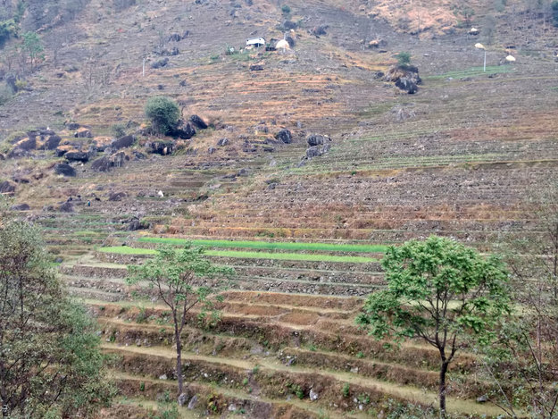 Areas such as these in the picture still appear as green cover and vegetation in satellite imagery. It is through closer field observation, can complete changes be discerned
To tackle such complex issues of land abandonment, interdisciplinary collaborations are sometimes required for proper understanding the reasons behind land utilisation. Such interdisciplinary collaborations are sometimes a complicated venture. Following such a route could mean you have to work in a team comprised of experts in different fields, which can lead to issues due to the differentiated jargon being used.
On the other hand, sharing knowledge across disciplinary boundaries has benefits as well: not only providing transformational thinking about complex problems, but creatively strengthening of single disciplines as well. Seeing other backgrounds and hearing other perspectives can give us the necessary energy, we need to tackle complex problems in our own fields. The nexus approach is one such way of open collaboration in understanding issues on migration and geographic information.
Note: The title of this blog is inspired from a book ‘People and Pixels: Linking Remote Sensing and Social Science’ (Liverman and National Research Council (U.S.), 1998)