By S M Tanvir Hassan, Bangladesh Centre for Advanced Studies (BCAS)
In recent years, people living in the Indus, Ganges and Brahmaputra (IGB) basins have been experiencing frequent floods. The floods affect their livelihoods and assets, including houses. It has been projected by climate scientists that owing to climate change the frequency and severity of floods here will increase in the near future. Hence, it is crucially important to test climate- and flood-resilient (CFR) houses for the poor people in the IGB region.
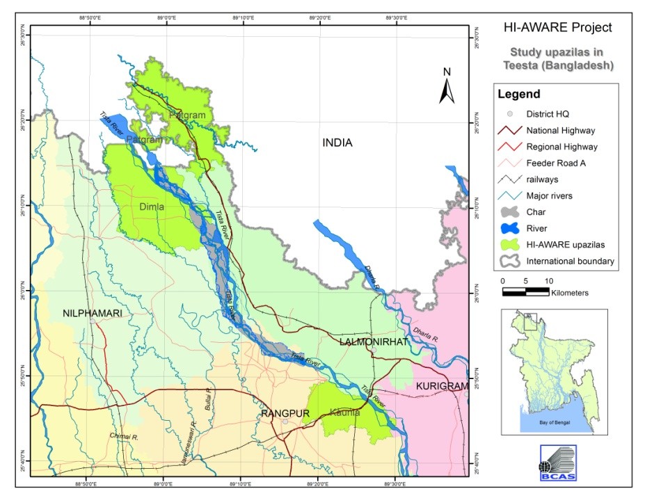 The location of the study areas in the Teesta floodplains in Bangladesh
In HI-AWARE Research Component 3, Task 3.3 will create robust evidences on the effectiveness and applicability of adaptation practices. These robust evidences will be created on the basis of piloting and monitoring in the food, health, housing, and energy sectors and target relevant adaptation approaches like climate-smart agriculture, resilient housing designs and smart energy grids. The piloting of CFR housing options will follow a participatory and multi-disciplinary approach to ensure it is technologically sound and socio-culturally appropriate. A team composed of experts in the related fields is working together on the piloting of CFR houses. The communities as well as other stakeholders are also engaged in the process.
A participatory approach was followed in selecting the villages for the piloting and in demonstrating the CFR houses. To ensure that, different geophysical, socioeconomic and environmental characteristics would be covered and studied thoroughly, sites that met the required were picked (Figure 1). Dimla, Kaunia and Patgram upazilas were selected from Nilphamari, Rangpur and Lalmonirhat districts, respectively, in the Teesta floodplain. Patgram, where the Dohogram union is exposed to regular flooding by the Teesta on the left bank, was selected as an upstream region; Dimla, where most of the area is protected by an embankment with spurs on the right bank, was selected as a controlled and midstream site; and Kaunia that includes vulnerable char islands inside and near the river, and where a number of adaptations in agriculture and housing are practiced, was selected as a downstream floodplain site. A BCAS study team conducted a field trip to visit the offices of government (GOs) and non-government organisations (NGOs) of the selected upazilas. Between 7 and 14 December 2015 (Figure 2), the team conducted interviews and group discussions with key informants and the communities of a number of villages that had been proposed by the stakeholders of the GOs and NGOs.
At the upazila level, during consultations with different GOs and NGOs, we studied following topics, as had been included in the checklist: (i) hotspots for riverbank erosion, floods and droughts in each study upazila; (ii) areas most impacted by extreme events; (iii) sector-wise vulnerability to extreme events; (iv) existing community and national level adaptation and coping strategies in the vulnerable region; (v) institutional capacity and response to riverbank erosion, flood and drought; (vi) government and institutional failure to address the vulnerability and mitigate the effects of climate shocks; (vii) available livelihood options and their status during flood, drought and riverbank erosion; and (viii) common housing patterns and infrastructure system practices.
The GOs and NGOs of each upazila that were considered to be potential stakeholders were (i) the Upazila Administration Office (UNO); (ii) the local government engineering department (LGED); (iii) the Department of Public Health Engineering (DPHE); (iv) the Department of Agricultural Extension (DAE); (v) the Project Implementation Officer (PIO) of the Upazila Administration Office; (vi) the Bangladesh Rural Development Board (BRDB); (vii) the Department of Social Services; (viii) the Department of Livestock; and (ix) the Department of Fisheries offices. We visited the offices to conduct individual interviews, to learn about their activities related to CFR housing and other adaptation practices in the study area. From earlier discussions, the most flood-affected union and villages had been prioritised for the visit and for community-level consultations.
For the community-level group discussions, the checklist mapped the following topics: (i) types of extreme events faced by the community; (ii) timing of different events such as riverbank erosion, floods and droughts in the community; (iii) how livelihood assets were affected by riverbank erosion, floods and droughts; (iv) vulnerabilities of the community due to riverbank erosion, floods and droughts; (v) gender-differentiated vulnerabilities; (vi) status of food, drinking water and sanitation during floods; (vii) existing coping and adaptation options and their effectiveness; (viii) livelihood opportunities (vegetable, poultry, livestock) during riverbank erosion, floods and droughts; (ix) existing adaptation practices and the adaptation capacity of the community; and (x) types of housing, water supply and sanitation infrastructure and their climate- and flood-resilient capacity. The vulnerability of the village and community to different extreme events, especially floods, was identified.
After the interviews and group discussions with the stakeholders, from the upazila to the local level, seven villages were proposed as potential sites for piloting and demonstration of CFR housing options in three study upazilas of the Teesta basin in Bangladesh (V1 to V7 in Figure 2).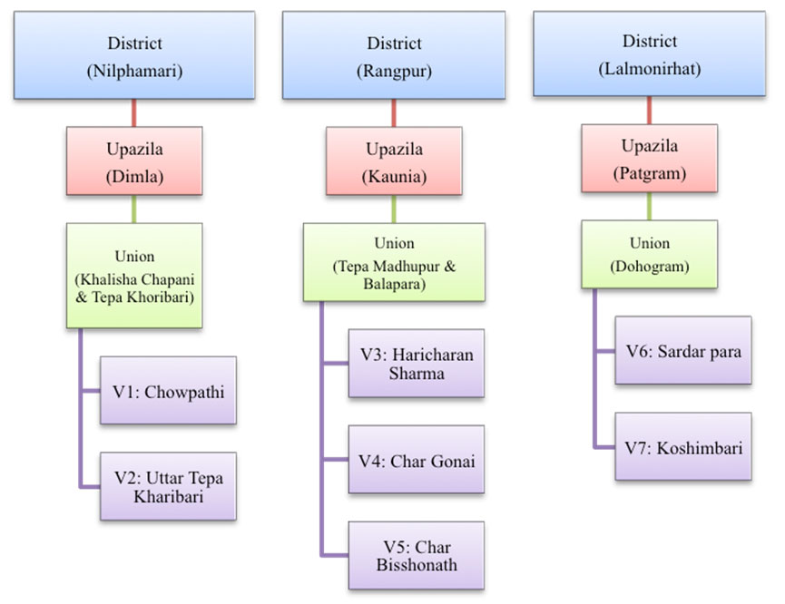 The sequential process of selecting villages for the CFR houses piloting.