Understanding the hydrological aspects of the Himalayan Rivers is important for water resource planning and development. The transboundary Gandaki River originates from high altitude areas of Nepal (and few tributaries from China) and flows downstream to the Indo-Gangetic Plain before meeting with the mighty Ganges. The river basin contains too much water during the monsoon season and too little during non-monsoon months. In order to understand the water balance in the basin, a study was conducted by Santosh Nepal and his colleagues Saurav Prdhananga and Ajay Bajracharya. The details of this study were shared on the 10th of April, at the Third International Conference on Mountain Hydrology and Meteorology for Sustainable Development in Kathmandu, Nepal.
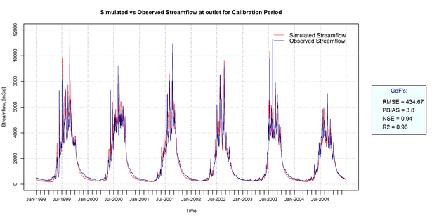
 Simulated hydrograph a) calibration period (1999-2004) and b) validation period (2005-2009)
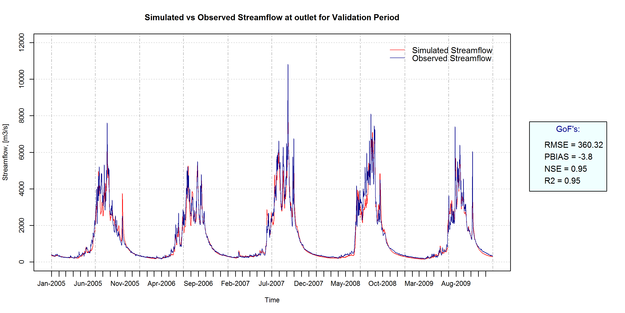
In the study, a process oriented J2000 hydrological model is applied to the Gandaki river basin (31,776 km2) to understand different water balance components. The J2000 model represents the flow from glacier areas and can segregate seasonal snow melt and glacier ice melt. We used data from 21 precipitation and 4 climate stations as input to the model. The model was run on a daily basis from 1998 to 2009 in which the calibration was from 1999 to 2004 and validation was from 2005-2009. The model results were compared with observed streamflow of various percentile values representing different parts of the hydrograph. The best results were achieved while supplying 15% additional precipitation to observed stations during the monsoon season, suggesting underestimation of precipitation in measuring station. For the calibration period, the Nash Sutcliffe efficiency and co-efficient of determination (r2) was 0.94 and 0.96, whereas it was 0.95 and 0.95 for the validation period. Overall, the model is able capture the hydrological dynamics of floods, high flow, mid-range flow and low flow very well.
 Spatial distribution of precipitation in the Gandaki river basin
The model has higher confidence in low flow conditions than in high flows. The glacier runoff contribution is about 13% (including 8% glacier ice) and snowmelt outside of glacier area contribution is around 9% of the total runoff. The overland flow contributed about 52% of the total runoff suggesting dominating processes of saturated and infiltration access runoff in the hillslope. The sub-surface and dry season flows contributed about 14% and 34% suggesting the significance of baseflow contribution to the basin. The evapotranspiration loss from the basin is nearly two thirds of the precipitation input.
The study shows a successful application of the J2000 model in the macro scale catchment in the Himalayan region and the spatial distribution of water balance information is useful for water resources planning and management such as irrigation and hydropower.
To gain access to a copy of the presentation click here.